Miles: 51
Perhaps the most jagged route of the trip...
...Day 3 was filled with two touches of the ocean, riding with a new acquaintance, a Dover detour, and the picturesque Maine countryside.
We woke early in order to get to downtown Portsmouth by 9:00am to meet Bob Spiegelman for breakfast. Bob is an ECG member and bike tourist extraordinaire. I got in touch with him after working with ECGA to set up our FirstGiving page. In addition to giving fundraising advice, he offered to ride with us when we came through Portsmouth.
.JPG)
The way into town was a pleasant meander through Rye, partially along the ocean.
Although one has breakfast nearly every day, one does not get to have one of the "best breakfasts in America" everyday. This is the distinction given to The Friendly Toast by various media entities. I'll add to the mix by saying that it was very good. And very good food is even better on a bike trip.
A Tale of Four Bridges...Well, Just One, Really...But the Three Others Make Cameo Appearances
Portsmouth is on the Piscataqua River. Four bridges cross the river from the city: one to New Castle Island and three to Kittery, Maine. One of those three is I-95. The other two are the Sarah Mildred Long Bridge, carrying US 1 bypass, and the Memorial Bridge, carrying US 1 business.
The ECG route is on the Memorial Bridge. When it was opened in 1923, a five-year-old named Eileen Foley cut the ribbon. Eventually, the bridge needed to be replaced. The new bridge opened August 8, 2013, also known as one week after Eve and I were there. And when it opened, a 95-year-old named Eileen Foley cut the ribbon. Somewhere along the way, Eileen had been elected mayor. Neat, eh?
The ECGA was there for the grand opening. Part of the celebration of the new bridge's innovative design is the fact that it features 5-ft. bike lanes and 6-ft. sidewalks in each direction. (The original had boardwalks but no bike lanes.)
That is all well and good for the next 90 years of walkers and cyclists, but on July 30, 2013, we needed to find a detour. But Bob knows the bikeability of the roads in the region better than anyone.
.JPG)
This bridge is next to the Little Bay Bridges, which carry the Spaulding Turnpike over the river. An NHDOT project to widen the Little Bay Bridges to eight lanes, consolidate nearby turnpike interchanges, and -- importantly, for us people on bikes -- rehabilitate the historic Sullivan bridge for continued active transportation and recreation -- was under construction.
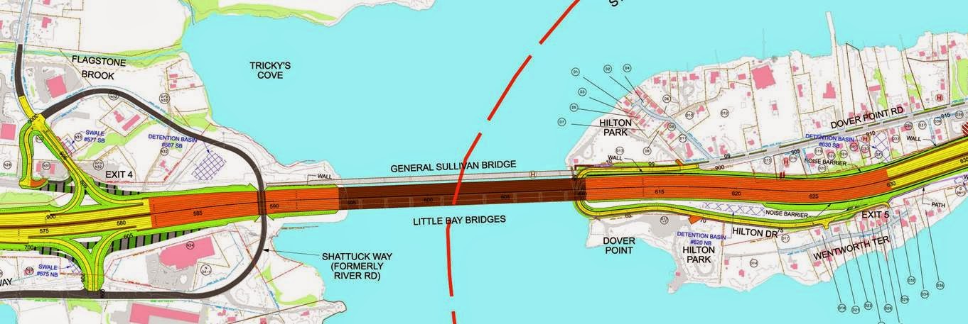
Source: NHDOT
After crossing the bridge, we were still in New Hampshire, on a peninsula separating Little Bay to the west and the Piscataqua to the east. Dover Point and Spur Rds. served as suitable western parallels to the turnpike, and New Bellamy Ln. allowed us to cross under it. At this point, we made a wrong turn that led us a half-mile south -- Bob's navigational skills took a short break! -- but before long we were pointed north to Dover.
.JPG)
.JPG)
Founded in 1623, Dover is "the oldest continuous settlement in New Hampshire and the seventh oldest in the United States" (Dover Public Library). The Cocheco River flows through downtown, and along it, Dover residents can enjoy the Joe B. Parks Riverwalk and Public Gardens, planned by the eponymous local horticulturalist and built by volunteers. There is also a community trail that runs north and south, crossing the river and serving the Amtrak station.
After the respite, we traversed the somewhat hilly terrain along Cocheco St. and Gulf Rd., heading generally downward to the Salmon Falls River, the NH-ME border. Naturally, the conversation focused on hills. Personally, of the many "banes" of cycling, hills are my least favorite. Growing up in Milwaukee, and having become a regular cyclist in the Twin Cities and Chicago, I'm perfectly comfortable with cycling in city traffic. You can probably guess, then, that I don't mind cold weather cycling (you just need to put on the right clothes). Rain can be annoying. But it's the hills that most make me wish I was riding an E-bike. When I lived in Carrboro, I used to nickname all the steep hills -- primarily as a psychological device to distract from the annoyance of the climb. No cyclist likes an uphill; at best, they are tolerated, or seen for their fitness value. Bob, the experienced bike tourist, reminded us that not all downhills are a breeze. Depending on the grade and turns, you might be doing a lot of braking. Bob recalled a long downhill on one of his trips: his hands eventually ached so much from squeezing the brake handles that he had to walk his bike a while, downhill, in order to rest them.
.JPG)
From here, it was 20 miles northeast through the bucolic southern tip of Maine to the Atlantic Ocean at Wells.
The Eastern Trail
In South Berwick, we rejoined the Eastern Trail after the construction-related detour around Kittery. Part of the East Coast Greenway, the Eastern Trail is 65 miles of on- and off-road route from Strawberry Banke in Portsmouth to Casco Bay in South Portland.
 (Source: Eastern Trail Alliance)
Our main navigational aid was the Eastern Trail Guide, a very helpful and clear binder of segment maps and cue sheets created and kept up-to-date by the Eastern Trail Alliance (see links above). Twists and turns, frequent road name changes, and construction and traffic alerts are all part of this fantastic guide, which is sized to fit in handlebar map holders. (Paper maps are especially helpful in areas where you don't have great mobile service and aren't bringing along expensive GPS equipment.)


Halfway to Wells, Bob bid adieu and turned to head back to Portsmouth. It was great to have him as a traveling companion for a half-day, in addition to his pre-ride advice on fundraising for the ECGA for our trip.
Our destination was the Ocean View Cottages & Campground in Wells, which had a nice wooded tent camping area. We set up the tent, took a nap, unloaded our panniers, and went to fulfill our hunger at Billy's Chowder House, on the edge of the Rachel Carson National Wildlife Refuge.
.JPG)
.JPG)
Wells was bustling with vacationers, many from Canada, it seemed. It was the farthest north beach with water still warm enough for most people's comfort. The campground was full of excitement. And the Rachel Carson NWR provided a nice contrast in its tranquility. There is beauty in town and beauty in country; touring cyclists can embrace both along their journey, sometimes right next to each other.

No comments:
Post a Comment